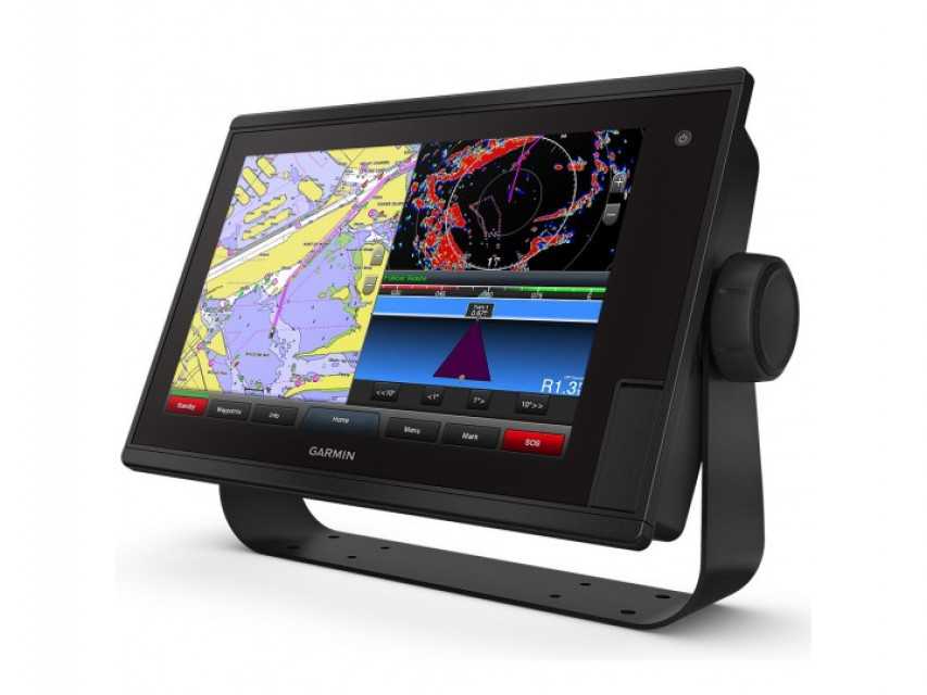
Garmin Gpsmap 1242 Touch - Advanced Marine Chartplotter with Full Networking Capabilities
Garmin Gpsmap 1242 Touch - Advanced Marine Chartplotter with Full Networking Capabilities
| Country of Origin | United States |
| MOQ | 1 Units |
| Price | USD 1689.99 / Units |
| Category | Electronics & Electrical Networking Devices |
Contact Garmin Gpsmap 1242 Touch supplier for wholesale b2b price, customization or other inquiries
Post Buy Requirement
Get quick response from worldwide suppliers
Garmin Gpsmap 1242 Touch
Automart Marine proudly presents the Garmin Gpsmap 1242 Touch, a cutting-edge 12" touchscreen chartplotter designed for coastal cruisers. This exceptional device comes preloaded with BlueChart g2 charts and LakeVü HD maps, offering market-leading features such as Depth Range Shading and Shallow Water Shading.
The GPSMAP 1242 Touch provides a comprehensive marine system solution, with full networking capabilities that allow you to seamlessly integrate radar, autopilot, sonar modules, instruments, and sensors. It even supports additional accessories like FLIR cameras, GRID™ keypad, GXM™ 53 marine weather receiver, FUSION-Link™ audio system, and VIRB® camera streaming. With network sharing, you can effortlessly share data among all compatible units connected to the network.
The built-in Wi-Fi® enables convenient use of the ActiveCaptain app, enhancing your marine experience.
Featuring a 12" fully network-capable touchscreen, the GPSMAP 1242 Touch offers unparalleled usability and control. Its preloaded BlueChart® g2 charts and LakeVü HD maps deliver outstanding features such as Depth Range Shading and Shallow Water Shading, ensuring you have accurate and detailed information while navigating.
The full networking capabilities of this chartplotter enable seamless integration with your entire marine system, allowing you to share data effortlessly among all compatible units connected to the network. Additionally, the GPSMAP 1242 Touch supports optional sonar modules, including the revolutionary Panoptix™ all-seeing sonar, providing you with a comprehensive view of the underwater environment.
Managing your marine experience has never been easier with the free all-in-one ActiveCaptain™ app, which allows you to control and monitor your Garmin devices from virtually anywhere.
With exceptional Garmin cartography, the GPSMAP 1242 Touch comes preloaded with LakeVü HD inland waters mapping and BlueChart g2 coastal charts, covering a vast range of locations in the U.S. LakeVü HD offers highly detailed freshwater maps, including over 17,000 U.S. lakes, rivers, and reservoirs, with more than 13,000 HD lakes featuring up to 1' contours.
For an enhanced experience, you can upgrade to LakeVü HD Ultra with Max Def Lakes, granting access to the Auto Guidance¹ feature, sonar imagery, and more. The BlueChart g2 HD package encompasses the East Coast, West Coast, Gulf of Mexico, U.S., and the Canadian side of the Great Lakes, providing basic coastal charts, tidal and current stations, depth contours, IALA nav symbols, and fishing charts.
To unlock even greater capabilities, upgrade to BlueChart® g2 Vision® HD, which grants access to Auto Guidance¹ and additional features.
Create personalized HD fishing maps instantly with the built-in Quickdraw Contours feature of the GPSMAP 1242 Touch. With 1' contours, you can tailor the maps to suit your specific needs, allowing you to accurately navigate and identify fishing spots. These maps are entirely yours, and you can choose to keep the data private or share it with the Quickdraw Community. The possibilities are endless with this powerful tool at your disposal.
The GPSMAP 1242 Touch is the cornerstone of your marine system, seamlessly integrating with the Garmin Marine Network, NMEA 2000®/NMEA 0183, J1939, and built-in ANT® connectivity. This comprehensive network allows you to connect and share data with radar, autopilot, sonar modules, instruments, sensors, FLIR cameras, FUSION-Link, VIRB camera streaming, and more.
By utilizing network sharing, you can easily exchange information among all compatible units connected to the network, enhancing your situational awareness and overall marine experience.
Experience the ultimate in connected boating with the GPSMAP 1242 Touch. Thanks to its built-in Wi-Fi, you can effortlessly connect to the free all-in-one ActiveCaptain app, which revolutionizes the way you manage your marine adventures. From your compatible mobile device, you can access your Garmin chartplotter, charts, maps, and the boating community, ensuring you have unlimited access to your cartography and the ability to purchase new maps and charts.
The ActiveCaptain app also offers smart notifications on your chartplotter screen, allowing you to stay connected wherever you are. You can plan trips, prefish lakes, and sync the data seamlessly with your chartplotter. Stay up to date with software updates and decide when to download them on your device, keeping your Garmin products at their best.
Sailing enthusiasts will appreciate the built-in SailAssist features of the GPSMAP 1242 Touch. With a prerace guidance page, you can optimize your wind strategy, displaying vital information such as virtual starting lines, laylines, time to burn before the start, and a synchronized race timer across all networked Garmin GPS products.
Other supported sailing features include an enhanced wind rose, heading and course-over-ground lines, set and drift, true and apparent wind data, and more. Gain a competitive edge on the water with these valuable sailing tools.
Experience the fluidity of movement on the screen with the GPSMAP 1242 Touch's fast and responsive 10 Hz GPS and GLONASS receiver. It refreshes your position and heading 10 times per second, providing you with accurate and real-time information. With up to 5,000 accurate waypoints, you can confidently navigate and find your way back to your desired locations.
Included in the box are the GPSMAP 1242 Touch chartplotter, power/data cable, NMEA 2000® T-connector, NMEA 2000 drop cable (2 meters), bail mount kit with knobs, flush mount kit with gasket, protective cover, trim piece snap covers, and documentation.
The GPSMAP 1242 Touch offers a range of connections, including Garmin Marine Network™ Ports (2), transducer ports (1 - 12 pin), NMEA 2000® port (1), NMEA 0183 input ports (1), NMEA 0183 output ports (1), video input ports (1 BNC), video output ports (1 HDMI), and wireless connectivity.
| Payment Terms: | PayPal, Bank Transfer, Credit Card |
| Packaging Info: | DHL, UPS, EMS, FedEx International Courier |
| Delivery Info: | 14 - 21 Business Days |
Product Specification
| Brand Name : | Garmin |
| Model No : | 1242 Touch |
Product Usages
The Garmin Gpsmap 1242 Touch is designed to enhance your marine experience by providing advanced navigation, networking, and connectivity features. This versatile chartplotter is primarily used by marine professionals, coastal cruisers, and boating enthusiasts who require reliable and comprehensive navigation tools.
With its 12" fully network-capable touchscreen, the GPSMAP 1242 Touch offers intuitive operation and allows users to build a complete marine system by seamlessly integrating radar, autopilot, sonar modules, instruments, sensors, FLIR cameras, and more. It is ideal for users who want to explore coastal areas, lakes, and rivers with confidence, thanks to its preloaded BlueChart g2 charts and LakeVü HD maps.
The GPSMAP 1242 Touch also supports optional sonar modules, including the revolutionary Panoptix™ all-seeing sonar, providing users with an unprecedented view of the underwater world. Additionally, the built-in Wi-Fi® enables users to access the free all-in-one ActiveCaptain app, manage their marine experience remotely, and stay connected to the boating community.
Product Keywords: Garmin Gpsmap 1242 Touch price, Garmin Gpsmap 1242 Touch wholesale, Garmin Gpsmap 1242 Touch supplier, Garmin Gpsmap 1242 Touch exporter, Garmin Gpsmap 1242 Touch trader, Garmin Gpsmap 1242 Touch customization, Marine Chartplotter, Ship monitoring display, marine navigation display
Product Images
Supplier Info
| Company Name | : | |
| Business Type | : |
|
| Supplier Phone: | : | +6287739xxxxx |
Supplier Info:
Automart Marine
 Jawa Barat, Indonesia
Year Established: 2008
Business Type:
- Wholesaler
- Exporter
Contact Supplier About This Product
Contact Supplier for product pricing, customization or other inquiries
Send Your Message to: Automart Marine
More Products From This Supplier
Related Products
-
- Price: USD 200 / Piece
- MOQ: 100 Piece
-
- Price: USD 6500 / Pieces
- MOQ: 1 Pieces
-
- Price: USD 5700 / Piece
- MOQ: 1 Piece
-
- Price: USD 653.17 / Piece
- MOQ: 10 Piece
- CISCO 9000
- Network Fault Monitoring RTU for Disconnection and Power Failure
- Milerd Aero Q8 Air Quality Detector
- BL200Pro Distributed IO Module
- 4GE+4WIFI+1POTS+1USB 5dBi 4 Antennas AC XPON GPON ONU For ZTE
- 4port EPON OLT L3 with WEB GUI
- Fanless Network Appliance Hardware Plugs Sfp Rj45 Networking Ports
- DR40X9, IPQ4019
- DR8072A WiFi 6E Card
- Dual-band USB wireless card WIFI receiver transmitter wifi adapter
- 2U Rackmount Chassis JYE-2811
- Temperature and Humidity Monitoring Solution
